
25 July 2005
Are WE in Shape?
As we relaxed upon the summit of Black Cap mountain just 30 minutes after hitting the trail, which our map called "a steep hike, one to two hours one way," we had to ask ourselves the question, "Are the books wrong, or are we in shape?"
After devotedly practicing yoga several times a week for over a year, one would think one would be in better shape, but one is always surprised to see the evidence of this in such an alarming fashion.
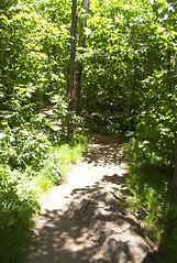
The hike was only a mile. The elevation gain was only 700 feet through the maple and beech forest before summiting.
We've agreed on a combination of truths: the times listed must be inclusive for families hiking with small children, and we walk at a pretty steady clip throughout the hike, meaning that yes, indeed, we are in pretty good shape. Maybe not the greatest shape, but better shape.
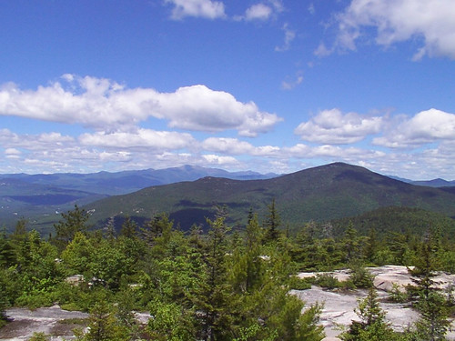
The summit was really lovely, with views of higher peaks as well as North Conway. The map also promised good blueberry picking, but that was another typo. While there were indeed blueberries, there were only enough for a handful here and there, not enough to fill our readied containers.
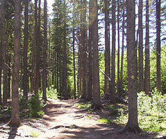
On the descent, we began to follow another trail that forked off titled Cranmore Mountain. We were about 1/2 mile in when we heard gunfire. It was very steady - Raf said it had to be a target range, not hunters - but it was also very nearby. Since we didn't know (only assumed) it was a target range, I pleaded that we head back just in case it was a psycho with a semi-automatic weapon in the woods. It didn't seem worth the risk. After all, this state's motto is "Live Free of Die."
The descent was anticlimatic because we drove 60 miles thinking we would be making a 3 to 4 hour hike, and only a little more than an hour had passed. We decided to try Cathedral Ledge, another 2 to 4 hour hike according to the map.
"That means one hour for us," said Raf.
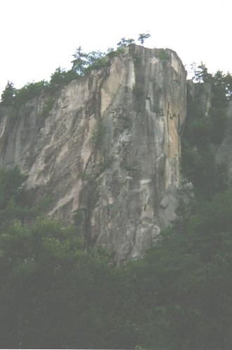
However, when we got to what we thought was the trailhead, we noticed several folks watching the face of the ledge. We identified the tiny colored specks on the ledge as the helmets of climbers in various states of ascent and descent. It was pretty cool. The maps and literature posted at the trailhead was all for climbers and instructions on ascending the different faces. We looked around. Everyone was wrapped in ropes and caribiners.
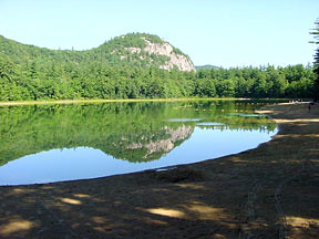
Figuring we were at the climbers', not hikers', trailhead, we head back for the car, and decided to drive on in search of where our trail started. We never did, for soon we found ourself at a dead end loop near the top. We parked near a sign that read "Fenced Viewing Area 500 ft." Alas! We were bummed. We had been looking forward to a good hike. I suggested we hike down and then up to the car, but Raf vetoed my idea. We took the dogs to the viewing area, and quickly left the fenced part for the more exciting and less popular un-fenced part. We scrambled down the giant boulders and overlooked Echo Lake and the White Mountains. For the tiniest split second I was almost overwhelmed with the desire to plunge head first off the ledge to see if maybe I could fly. Luckily, though, I remembered my yoga breathing, and within seconds felt one with my surroundings. Whew! Crisis averted. I had the car keys in my pocket.
After leaving the ledge safely in a the traditional fashion (for those without ropes and carabiners), we drove down to Echo Lake. It was about 5pm, the sun was still shining brightly, the beach was practically empty, and the water was lovely - quite a system shock when one is used to the euphemistically "refreshing" 58F water of Maine's beaches. I dashed into the woods and changed into my bathing suit, and we leashed the dogs up to a picnice table at the water's edge. Gamma Ray promptly found a shady spot under the table and took a siesta. Seamus, however, was distressed by many things. First off, there was a dog OFF-LEASH running along the beach about 500 yards away, so he barked at it, and he tried to drag the picnic table as he strained to go meet it. I scrambled into the lake and tried to distract him, which was somewhat successful. He seemed concerned that I was swimming away and he made his way toward me. Raf untied him from the picnic table, and threw me the end of 20 ft leash. I called him, and he distrustingly made his way through the shallow parts, trying to lift his paw over the surface each time, which promptly turned into trying to leap through the water. When it the water became deep enough, he resorted to the tried and true doggie-paddle, and quickly made a beeline toward the other OFF-LEASH dog, who was also swimming (but very focused on tennis ball retrieval with her owner), pulling me behind. Ever hear of skijoring? I was sure we were on to something new here. It was very cute. But I needed backup. Raf joined us in the water and swam way out. This redirected Seamus's focus, as he paddled over to her. Once he reached her, though, he turned right back to the shore. When he'd step out of the water, Raf would call him, and he'd leap back in (actually leaping at first before the depths forced him to resign to swimming), and once he'd reach her, he'd turn immediately back. After playing this game a few times, he tired of it, and took his place under the picnic table next to the very dry and content Gamma Ray, who wore a smug look on her face that said, "Why do you fall for it every time?"
After a lovely time at the lake, we dried off and got dressed and head to town in search of grub. We first swung off the highway to check out a little inn we had noticed last week called the Swiss Chalet Village, which had a big sign saying "Pets Welcome." We were just curious since it was so cute in a garish sort of way. Then instead of taking the highway on as we had planned, we drove up the little road the inn was on to see where it would lead us. Back to the highway, but closer to the town center, so we abandoned driving out of North Conway again and decided to find something in town to eat. We finally stopped at the Moat Mountain Brew Pub. When I get a chance, I'll review this in the Restaurants column, but let me just say we were totally non-plussed.
Of course, we stopped at Zeb's for our candy fix on the way out of town. I got licorie and a piece of fudge, and Raf got sour cola bottles. When we got back into the car, the dogs were fast asleep, and they slept most of the way home. We had so much fun once again, and we're planning on camping there Friday through Sunday next weekend if the weather's good.
Posted at 7:14 am
![]()
Paradise Island
This blog's purpose is part travel journal, part photo blog and part travel guide to St. Kitts and the Lesser Antilles. Please let me know if there's something about the island that you'd like to learn more about, and I will write about it here!
PREVIOUS POSTS
-->


GETTING HERE
The only major US airline that flies to St. Kitts is American Airlines. If you can't get one of those flights, just book a ticket to Puerto Rico, Antigua, or St. Maarten. There are two island airlines that I know of: Caribbean Sun Airlines and Liat. Both fly from all of those islands to St. Kitts. If you're coming from Europe, your best bet is to catch the daily Paris-St. Maarten flight on Air France, and then hop over to the island on a CSA or Liat flight.
If you'd rather float by boat, check out the Link Ferries, which specialize in island hopping.
ISLAND LINKS
I'm compiling a list of links for travellers to the island:
- Doctor Y/Doc Tory This is a link to a site put together by some friends who have lived on the island for several years. They have terrific pictures!
- Discover St. Kitts Nevis Beaches This is a link I found earlier in the year that gave me some information on what to do/where to go on the island. It's not the greatest, but the web presence here isn't terrific, either, so it does what it can. I also subscribed to their newsletter, but I didn't learn anything not already on the site. The site has some nice pictures, though.
Weather

1 Comments:
That sounds like a day well spent, and the scenery was certainly beautiful.
Post a Comment
<< Home